Happy day-before-Halloween. (All Hallow's Eve Eve?)
I've got a ridiculous amount of candy (though I'm in town now, and I'm not calibrated for trick-or-treaters other than the Small Human). I've got a costume for the Small Human. I don't have a costume for myself, however. (Small Human wants me to go as a bat. Given today's stories about the causes of white-nose syndrome, though, I don't have the heart for it. Poor little guys.)
A few years ago, I encouraged my intro class to dress up as something geological. I forgot to do it this year (and it worked better when the class suggested the idea), but I got to wondering...
What would be the scariest possible geologic costume?
I think I would have to go with liquefaction. There's an earthquake, the ground turns to quicksand, buildings and people sink into the ground, and then the sand solidifies around you so you can't breath.
And then the dogs come out and eat your head.
(Images of the 1692 Port Royal earthquake from http://www.longjohnsilvertrust.co.uk/projects/henrymorgan.htm .)
Braaaaaaaains.
I'm not sure exactly how the costume would work, though. I could encase myself in sandy plaster and stop breathing... but maybe that wouldn't be a good idea.
On second thought, maybe I'll go as some obscure geology jargon that deserves to be re-animated. Nothing like a good word to eat a brain.
Braaaaaaaaains....
Thursday, October 30, 2008
Spooky geology

Sunday, October 12, 2008
THAT wasn't the search result I needed...
I'm talking about earthquakes in my intro class tomorrow. Most likely, I will tell the story about my experience in 1989 (sitting in a doorway shouting "is this an earthquake?" - which, by the way, is not the currently recommended behavior). But part of me would like to show the GPS monitoring that's being done right now. (Not that I'm quite prepared to explain vectors to my intro students... though, come to think of it, the GPS map would be a great example for anyone teaching about vectors.)
I've had the Earthscope Plate Boundary Observatory vectors plugged into Google Earth for quite some time, but I didn't remember where I'd found it. So I did what I always do: I googled it.
And my blog showed up as the second hit.
So, for anyone who goes looking for "continuous GPS google earth," here are the sites you really want:
Google Earth plug-in
GPS products from the Plate Boundary Observatory
Earthscope: Plate Boundary Observatory
(And yes, I'm doing this because I know I'll lose track of the sites again, and I figure I can always search my own blog.)
Sunday, August 31, 2008
The blogosphere and the first day of class
Everything I'm doing on my first day of my intro class was inspired by the blogosphere.
There was a great post by Andy Revkin of the NY Times a few weeks ago, talking about disaster memory in elephants and humans. In a drought, old elephant matriarchs lead their groups to far-away water holes that don't dry up. Revkin makes the connection to human memories of disaster: are memories of what to do in a tsunami, or a drought, or a hurricane remembered? He comments that:
As I’ve said here before, it now seems in some ways that scientists are like society’s elders, with awareness of past disasters absorbed from years of studying mega-droughts recorded in tree rings, or coastal destruction etched in layers of sediment, or great earthquakes recorded in displaced stream beds.He says "scientists." I say "geoscientists," because every one of these examples is the sort of thing that we study. And in a world in which geology is often left behind by adults, limited to memorizing rock types in grade school, those of us who teach general education science courses may have the last chance to give people access to the wealth of knowledge that geoscientists have accumulated.
So that will be the theme of my course introduction: how humans deal with a planet that, though perfect for life, can also be deadly.
I'm going to show these images:

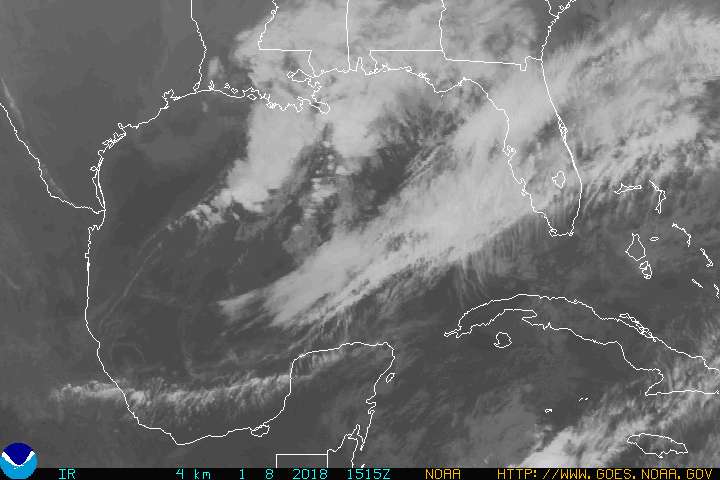
Hurricane Gustav late on Sunday, from NOAA. New Orleans has been evacuated. Buses carried away those who didn't have cars of their own. The Superdome and the Convention Center are thankfully empty. Even if the city floods again (which I hope it will not), hopefully New Orleans has averted a repeat of the horrifying tragedy of all those people, trapped in their homes with water up to their roofs, or stuck in the Superdome with no way to leave the city. Three years is manageable on a human time scale. The wounds have not yet healed. People remember.
But what about disasters that happen less frequently?

The town of Chaiten, Chile, buried in mud by volcanic mudflows after the eruption of Chaiten volcano. Thanks to The Volcanism Blog for this picture.
Chaiten volcano was a caldera, a great circular hole left by an ancient eruption. It had been 9000 years since it erupted last, but in May, when it came to life, the warning signs were clear. The town of Chaiten was evacuated. And 4000 people are still alive who might not otherwise have been. Perhaps Chaiten was close enough to the volcano that the people would have left. But other towns (such as Armero, Columbia in 1985) have been destroyed by similar processes. When disasters happen 9000 years apart, it is unlikely that human memory (even if cultural traditions have been passed on) will be sufficient to tell people what to do. But geologists can be like elephants. We can remember.
And sometimes memory of the past isn't a sufficient guide for the future.

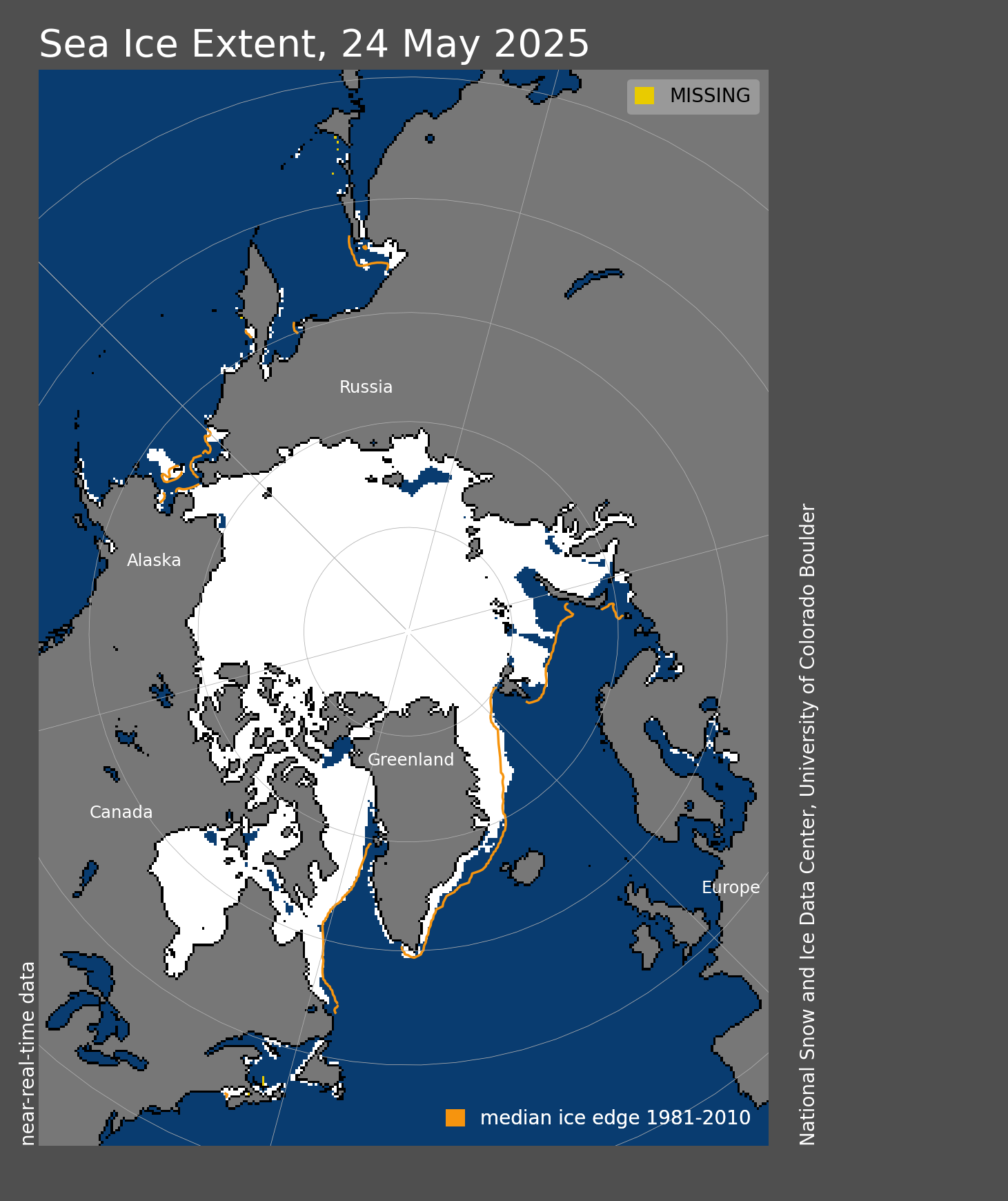
Extent of Arctic sea ice on August 30, from the National Snow and Ice Data Center.
Sometimes physical models provide guides when there is no obvious analogy in the past. The Arctic sea ice is melting. What does that mean, other than drowning polar bears, opportunities for new oil drilling, and arguments over who owns the floor of the Arctic Ocean? I don't have clear answers, but understanding the basics of climate science and oceanography can help make sense of what scenarios are more likely than others.
And then we come home to Durango.

I'm going to make them sketch and think about this picture while I find out who's in the class, and where they're from. I probably won't ask what kinds of stories their families tell, though I'm curious whether the Navajo students, in particular, understand some of their stories as warnings. (I have to show them how to use course management software and stuff as well. And remind them to buy the book.)
I stole the idea from Andy Revkin, and the examples from a recent post by Callan Bentley and older posts by The Volcanism Blog. Thanks, everyone, for good ideas. :)
Wednesday, August 27, 2008
Gustav and uncertainty
I'm watching the forecasts for Tropical Storm Gustav with dread.
Image: five-day track forecast for Gustav, from NOAA.
Three years ago this week, I began my first Earth Systems Science lecture with an image of a swirling cloud looming over the Gulf of Mexico. On the second day of class, I was asking students if they knew anyone from New Orleans, and whether they were all right. It was horrifying, particularly because I had used the geology of New Orleans as an example in classes for years, ever since I read The Control of Nature.
But even though Gustav appears to be headed on the absolute worst course for the city of jazz, levees, and elevations below sea level, Forecaster Franklin of the National Hurricane Center added this reminder to the end of Wednesday's 11 pm discussion:

IT PROBABLY WOULDN'T HURT TO REMIND EVERYONE THAT THE AVERAGE 5-DAY OFFICIAL TRACK ERROR IS ABOUT 300 MILES...AND THE AVERAGE 5-DAY INTENSITY ERROR IS ABOUT 25 MPH.
Error. In other words: there are reasonable odds that we'll be wrong, and the storm will hit Houston or the Florida Panhandle.
I'm not a statistician. In fact, I've never taken a statistics class. (I'm embarrassed enough to have bought an undergrad statistics textbook, but not shamed enough to have buckled down and worked through it.) But I am a scientist and a teacher, and that means that I need to somehow get students thinking about uncertainty.
I'm not a weather modeler, so I think about uncertainties more in the context of measurements than of predictions. I learned about the concepts of accuracy and precision in chemistry classes, and about error estimates in intro physics. My geology classes never took on the topic directly. But it should be possible to think about the ideas in geology, as well. How good is that bearing you measured on your compass? When should I count your answer as "wrong" - when it's half a degree from mine? One degree? Five degrees? Even if you weren't balancing on a cliff with shaking hands, would our measurements always be identical? When I talk about uncertainty in class, it's usually in that context.
Uncertainty in weather models is something I know less about. I know, from reading the discussion of the hurricane forecasters, that they look at the predictions of a number of different models (which presumably use different ways to weigh the effects of wind shear and warm Gulf water and other weather systems). I don't know where the 300 mile uncertainty comes from. (Is it the same kind of sense based on experience as I have about the correctness of my compass measurements? Or is there a more formal statistical way to derive the model's uncertainty?)
I hope that Gustav does not become a teachable moment. May the predictions be wrong, and may the storm weaken. And may everyone be prepared, in the event that it is correct.
Wednesday, May 21, 2008
NPR interview about aftershock prediction
NPR has an interview with Walter Mooney of the USGS about expectations for aftershocks of the Eastern Sichuan earthquake. It's a good explanation of what seismologists can predict (things like the size of aftershocks) and what they can't (the exact time of aftershocks). Mooney also talks about the stress changes that can trigger later earthquakes - science that's been developed in the nineteen years since I was in Loma Prieta (and heard Mooney, amongst other people, talk about what to expect).
All that knowledge doesn't help when villages are buried by landslides by the shaking, however. It sounds like the most difficult problem, as with natural hazards from California to Indonesia to New Orleans, is that there are a lot of people in the world, and most of them aren't able to choose a perfectly geologically stable place to live.
Friday, April 18, 2008
Mississippi River watch continued
At Natchez, Mississippi, the Mississippi is now one-tenth of a foot lower than it was in 1973.
Meanwhile, the New Orleans Times-Picayune has a long piece on what this flood could be doing for coastal restoration.
Tuesday, April 15, 2008
Lower Mississippi: flood stage comparable to 1973
From the National Weather Service:
928 PM CDT MON APR 14 2008
THE FLOOD WARNING CONTINUES FOR THE MISSISSIPPI RIVER AT NATCHEZ
* UNTIL FURTHER NOTICE.
* AT 8:00 PM MONDAY THE STAGE WAS 55.6 FEET.
* MODERATE FLOODING IS OCCURRING AND MODERATE FLOODING IS FORECAST.
* FLOOD STAGE IS 48 FEET.
* FORECAST...THE RIVER WILL CONTINUE RISING TO NEAR 56.5 FEET BY SUNDAY MORNING.
* IMPACT...AT 56 FEET...SOUTH OF NATCHEZ, BOURKE ROAD IS UNDERWATER. RESIDENTS WILL HAVE TO BOAT INTO THEIR HOMES.ALL HOMES IN THE TOWNSHIP OF FT. ADAMS ARE FLOODED.
* FLOOD HISTORY...THIS CREST COMPARES TO A PREVIOUS CREST OF 56.6 FEET ON MAY 13 1973.
edit: The NWS has raised the predicted flood crest to 57 feet. That's higher than 1973. Still less than 1927, the year that inspired Randy Newman's song Louisiana 1927. (It also inspired the Army Corps of Engineers to build the Bonnet Carre spillway, to let water out of the Mississippi before it flooded New Orleans.) /edit
The Old River Control Structure was nearly wrecked by the 1973 flood.
Meanwhile, the Bonnet Carre spillway, which lets water from the Mississippi into Lake Pontchartrain, has been partially opened, to keep the Mississippi near New Orleans from rising higher.
Monday, April 14, 2008
Gravity, rocks, mud, and the Big Snow Year
Headline of the week, from my local paper: Geologic forces plague East Animas Road.
Ten years ago, a big piece of Dakota Sandstone fell off the cliff on the top of the ridge north of town. For years, we would wave our arms at it, and tell stories about it to intro students. And then, in the fall of 2006, mud started to trickle out of the bottom of the rock fall. It had been a wet fall, and the finer grains were remobilizing into a debris flow.
One of out students did a senior thesis on the hazard. Usually when students predict something in geology courses, they don't see their predictions come true. Not so with this student.
When the snow melted this year, the mud came down with it.
East Animas Road has been closed for the past few weeks. I drove out there one afternoon to take pictures. Apparently there have been multiple feet of mud across the road at various times. There's a loader parked there, and it moves the mud out of the way, and then more comes down. Fortunately, there are no houses in the direct path, and the road has two outlets, so it's an inconvenience rather than a tragedy.
The mud is really slippery, too.
(And field camps who want to know where this is - e-mail me and I can give directions, and let you know if it's still running. The snow has nearly melted from that part of the ridge, so the mudflows may be done... for this year.)
Thursday, April 10, 2008
Watching the Mississippi basin
Has anyone else been watching the USGS flood map this spring?
This is what it looks like today, April 10.
There are at least three things that scare me on this map.
1) All those black triangles represent places where the rivers are above flood stage. Look how many of them there are!
2) Some of the places above flood stage include the Mississippi River at Baton Rouge and the Atchafalaya River at Morgan City. (Recommended background reading: "Atchafalaya" in The Control of Nature by John McPhee. For anyone who hasn't read it: the Atchafalaya River would probably be the main course of the Mississippi River by now, if it weren't for some massive engineering. The Old River Control Structure, which tries to let just enough water into the Atchafalaya to prevent floods in Baton Rouge and New Orleans, nearly failed in the 70's. It's been strengthened since then, but it hasn't faced huge floods, either.) Both places have been a few feet above flood stage for a week, at least.
3) Of the big tributaries of the lower Mississippi, only the Ohio is currently above flood stage. But it's still snowing across the Rockies, the northern plains, and Minnesota:
The Missouri and upper Mississippi drain areas where the snow hasn't melted yet.
I was frantically writing my dissertation in 1993, and water data wasn't on the web for daily ogling. I remember some discussion that the 1993 floods on the upper Mississippi and Missouri didn't result in danger for Louisiana because the Ohio basin was fairly dry that summer.
I hope the Ohio goes down before the Missouri and upper Mississippi rise.
Edit: The National Weather Service flood warning for Natchez, Mississippi (above the Old River Control Structure) says the Mississippi should crest just below the level of floods in 1983:
THE FLOOD WARNING CONTINUES FOR THE MISSISSIPPI RIVER AT NATCHEZ
* UNTIL FURTHER NOTICE...OR UNTIL THE WARNING IS CANCELLED.
* AT 8:00 PM WEDNESDAY THE STAGE WAS 54.4 FEET.
* MODERATE FLOODING IS OCCURRING AND MODERATE FLOODING IS FORECAST.
* FLOOD STAGE IS 48.0 FEET.
* FORECAST...THE RIVER WILL CONTINUE RISING TO NEAR 55.5 FEET BY
TUESDAY MORNING.
* IMPACT...AT 55.0 FEET...FORT ADAMS POND ROAD IS FLOODED.
* FLOOD HISTORY...THIS CREST COMPARES TO A PREVIOUS CREST OF 55.7
FEET ON MAY 31 1983.
According to John McPhee (Control of Nature, p. 53), the 1983 flood was the 3rd largest of the 20th century. (1973 was the year the Old River Control Structure nearly failed.)
Monday, October 15, 2007
Accretionary Wedge #2: How the Earth Could Kill You
Civilization exists by geologic consent--subject to change without notice.
Apparently there is some controversy about whether Will Durant ever actually wrote that quote. But that doesn't really matter to geologists. We know it's true. Just ask the ammonites, or the residents of Pompeii.
But how, exactly, might the death and destruction occur?
Volcanoes
Chris Rowan at Highly Allochthonous sees warnings for Naples, Italy in"A Tale of Two Volcanoes".
And on the North American plate, Yami at Green Gabbro takes a not-quite-boiling soak in the hot springs created by the magma of the Long Valley caldera.
And if the volcanoes of recent history are too tame, consider the Cretaceous-Tertiary boundary. The asteroid impact gets most of the press these days, but Chris (yorrike) at Good Schist points out that the volcanoes of the Deccan Traps did a number on the ammonites first.
Earthquakes
And I wasn't killed by the Loma Prieta earthquake (as you might have guessed), but I was shaken up a bit.
Landslides
Hazards in general
It isn't just gravity. As Jim Repka at Active Margin points out, we wouldn't be able to live without disequilibrium. That's right. Thermodynamics is also out to get us.
And then there are the hazards of field work...
Those of us who live in arid or semi-arid environments know that the sun is not always our friend. Especially at noon in the summer. Lounge of the Lab Lemming has more about deadly evapotranspiration.
And Ron tells of a field assistant with walking pneumonia on the dreaded Mancos Shale, and also warns that the Earth is hungry.
So watch out.
The next edition of The Accretionary Wedge will be on November 15. Kevin Z at The Other 95% will be hosting the carnival, with a theme of "Geology and Life."
Also, an announcement for any geo-bloggers and lurkers who will be going to the GSA meeting in Denver in a few weeks: there are plans afoot for a geo-blogging meet-up/dinner on Sunday night. Ron has offered to make dinner arrangements. Keep a look out for the final arrangements.
Edit: I'm adding other posts as they come in. So far, Jim Repka has added dire warnings about equilibrium, and Dr. Lemming tells of the dangers of evaporation.
Thursday, October 4, 2007
Landslides, nature, and the blame game
There was a big landslide yesterday near San Diego, California. Landslides in coastal California are not at all uncommon – the mountains are steep, and young, and many of them are made of rock that falls apart easily. So I wasn’t surprised to hear about it, but my students asked about it this morning, so I looked it up on CNN.
And at the bottom of the story, I found this:
Pat Abbott, a retired geological sciences professor at San Diego State University, told the Union-Tribune that Mount Soledad is made up of weak layers of rock and that the culprit in the landslide is nature.
Now, a bit of background may be in order here. Local residents are blaming the city for the landslide – they claim that the city didn’t repair leaky pipes, including a fire hydrant, and that the water caused the landslide. So Abbott pointed out the geologic background of the area, which makes it particularly prone to landslides: the mountain is underlain by weak layers of sedimentary rock that slope in the same direction as the hillside. In other words, the hillside was going to slip someday. (In fact, there was a landslide in the 1960’s when the area was first developed, and there were two landslides in the 90’s.)
But the quote on CNN’s web page doesn’t go into that background. Instead, it simply says “the culprit... is nature.”
There’s something about that statement that suggests the inevitable, the uncontrollable, the unpredictable. There’s nothing we can do. It’s natural. It reminds me, actually, of statements by Robert Murray, owner of the Utah mine that collapsed in August. (He tried to avoid blame by arguing that the collapse was natural - in that case, that it was the result of an earthquake.) If nature is at fault, then how could a mere human have done anything?
But I don’t buy that. Nature isn’t wholly unpredictable. Sunrise and sunset are natural. So are tides. And so, for that matter, is gravity... which is ultimately the cause of both landslides and mine collapses. Now, the response of earth materials (be they coal or soil) can be difficult to predict, but that doesn't mean we know nothing - it simply means that we can’t draw a single clear line between “safe” and “unsafe.” And hillsides that have slid before fall into the category of “probably unsafe... eventually.”
So do I think the city is responsible? Probably not (although adding water to a dangerous slope could change a slope from “potentially unstable” to “oh s*** let’s get the heck out of here”). But I don’t think that a sense of fatalism is the only other possible response.
Nature can be dangerous. And it’s more dangerous in some places than others. And we already know a lot about where those places are.
So maybe people should pay attention to dangerous geology. On steep hillsides, yes, but also in flood plains, and along coasts. Because losing a house is horrible and tragic, and it would be better to avoid it happening in the first place.
Pat Abbott (who is also the author of a textbook on natural hazards) knows this, by the way. The CNN story ends like this:
"Gravity pulling on the incline is pulling down masses of earth and those masses of earth have houses on top of them," Abbott told the paper. "It's a geologically bad site and should not have been built on to begin with."