I love field work. No, really, I do. But when I tell stories about it, they always end up being about running out of food or wrecking vans or collecting samples of giant mosquitoes by slamming a field notebook shut or not being able to find a single sample of high-pressure metamorphic minerals except trapped as inclusions in a garnet. (And that was just my PhD area.) I've thrashed through ice-storm-damaged woods, taking an hour to walk a mile, in search of non-existent staurolites. I've fallen into streams. I've broken a canoe paddle while trying to cross a melt-swollen river. I've post-holed through snow banks. I come back from the field covered in mud, sweat, scratches, bruises, and occasionally blood from where my hammer missed the chisel and slammed the back of my hand.
Which makes me wonder, while lying in a tent with an aching back and wondering whether that sound outside is a hungry bear or just a vole with insomnia, whether it's worth it.
Then I come back to the human world, where people care about things like other people's shoes*, and I think: worth it? Are you kidding?
Photo: me, someplace where the temperatures are cold and the rocks are hot. In other words: someplace close to heaven.
(For the November Accretionary Wedge.)
* Edit: a story, in explanation. In my second or third year in my previous job, I was a junior faculty member on one of those campus-wide committees. Before one snowy winter meeting, I found myself outside the meeting building with the committee chair, a faculty member in another department on campus. She said to me: "Isn't the etiquette of Vermont winters funny? It's inappropriate to look at other people's shoes until they've had a chance to change them." I was flustered and had no idea what to say; I generally changed into indoor shoes because my winter boots were snow-covered, muddy, and made my feet sweat. It had never occurred to me that I was being judged by my footwear.
I failed to successfully negotiate the social boundaries between effective teaching, interesting research, and the expected image of a female faculty member. My favorite field area was in northeastern Vermont - although it was in dense, bug-filled woods, it was the first place where I found surprising results and struggled through to models that were my own, not my advisor's or another mentor's. And I haven't been back there since I was denied tenure.
I've found a new, beautiful place to work. I haven't had the thrill of finding things that are unexpected yet. But there are beautiful views, and in Durango, nobody cares what I wear.
Saturday, December 6, 2008
Field work: this might be heaven or this might be hell

Wednesday, November 19, 2008
Field nightmare
I dreamed about teaching field camp last night.
I've taught field camp in several places, but one of my favorites is near Hoback Junction, Wyoming. We camp in this Forest Service campground with views of the Wind Rivers and a hot spring just up the road. The road up to it was in bad shape last time I stayed there, but it's still a gorgeous spot.
The problem with the campground, at least the last time I stayed there, was that you can't make reservations ahead of time, and there's no group site, so it's possible that we won't find a good spot for all the students to camp near one another.
And that's how my dream started. We got to the campground fairly late, only to find that three-quarters of it was closed off with deep piles of snow still on the ground, and all the remaining sites already filled. We drove around looking for a spot, and ended up trying to turn around somewhere down at the end of one of the campground loops.
And that's where we met the RV. It wasn't just any old RV. It was... well, it was immense. Bigger than an 18-wheeler. Tougher than a tank. And driven by someone who didn't look where he or she was going.
The RV was headed straight for my Subaru*. And it didn't stop.
In the end, my Subaru was crunched to half its original length. (I woke up before considering the possible analogy between shortened Subarus and regional strain analysis of collisional tectonic belts.)
So: academic nightmares by geology professors. (At least I didn't dream that I showed up for field work a day late, with no clothes, and sat on a cactus.)
*Don't ask me why I was driving my Subaru at field camp. Normally I drive a 15 10-passenger van loaded with students and gear. And, yes, I have a complicated history with vans, which many people can tell stories about. But there wasn't a van in this dream.
Tuesday, August 26, 2008
What kind of compass do you prefer?
I see that eight nine people have already voted in the poll I put up yesterday, even though I haven't found time to blog about it until tonight.
I'm putting together my classes for this semester. (I don't start until Sept. 1, so I've got a few more days.) One of the classes I'm teaching is our sophomore-level field methods course. The title might be misleading - the course is an introduction to geologic mapping, and leaves out many other things that geoscientists do in the field. (In fact, my intro class will be doing some of them in their stream lab.) On the other hand, geology isn't just a set of technical skills that one is trained to do - a geologist should be able to imagine what's hidden underground*, as well, and the skills in this class are designed as one step towards developing the ability to think spatially.
Geologic maps show what rocks are found near (or at) the surface, but they also provide the information needed to make a good guess at what might be hidden underground. That information comes from the orientations of layers of rock, and of fractures and cleavages and faults. And to find that information, we still use big, clunky, old-school geologic compasses. (GPS is great for figuring out where you are, and we use those, too. But the compass is still a basic piece of equipment.)
When I was young (*shakes cane*), I learned to measure bearings by measuring angles from north or south:
If that arrow in the middle of the circle was... oh, let's say it's the direction a current used to flow. I would have measured the direction of the arrow as being 45 degrees east of south (or in my field notes, S 45 E).
But that's not the only way to measure angles. A circle can be divided into 360 degrees, and compasses can measure bearings around a circle, starting with north and then spinning through east (at 90 degrees), south (at 180 degrees), and west (at 270 degrees), and finally getting back to north, if they didn't get dizzy and fall down in the meantime. Those kinds of bearings are known as azimuths. They're easier to deal with mathematically, because they're one number, always measured in the same direction. They confused me when I first dealt with them, because I'm lousy at memorizing numbers. (I hate combination locks.) I've gotten used to them, though, because I've worked with people who prefer them.
I always used to think that quadrant measurements were more intuitive. I think about directions as "southwest", not as "a bearing between 180 and 270 degrees." And I carry a protractor that measures angles between 0 and 180 degrees easily, but which requires me to subtract larger numbers in my head. (And I make mistakes when I do arithmetic in my head.) I prefer to make my maps in the field - they are tools for helping me think about what's going on, and if I wait until evening (or later) to compile them, I might have to hike miles and miles back to the same spot to collect more data. And that means that my favorite compass is one that gives me numbers less than 180 degrees.
I've seen more and more students who are at least as comfortable with azimuth measurements as with quadrants, though. And at least three of my colleagues prefer them. (And I've got a sinking feeling that I'm just hideously old-fashioned for carrying a quadrant compass.)
I'm not going to trade in my compass. It was expensive, and it still works, and I'm capable of converting the different measurements. (I can almost do it in my head. If I practice enough. Grading 20 labs every week gives me lots of practice.) And I always make students convert their measurements back and forth. (I still need to do the math in my own head, though, to check them.) But I'm curious what the current trends really are. Does anyone prefer quadrant compasses, or are people switching entirely to azimuth? Are the azimuth people primarily geophysicists? (Paleomag is easier in azimuth, I believe.) Are azimuth bearings easier to handle in GIS?
And if I carry a quadrant compass, should I carry a sliderule, too?
*Yes, I realize that may be a structural geologist's bias, but you know... in grad school, I could have been a geochronologist or a metamorphic petrologist. I've become a structural geologist by necessity, because my departments needed someone to teach spatial thinking more than they needed someone to unravel the exhumation histories of metamorphic rocks.
Friday, June 13, 2008
Which town is visited by the most US field camps?
I met up with Ron for dinner tonight. His field camp has just finished their work in the Durango area. I grilled him for information on the spots where they map - I wanted to know why I see so many vans pulled over beside the same big roadcut every spring. (I have never taken my mapping classes to either of the classic Durango field areas, by the way. I have my own favorites, chosen for 1) nice views, 2) variety of rock types, and 3) interesting map geometries - one of them is perfect for getting students to think about features that dip upstream vs downstream.)
During the conversation, I wondered which towns were visited by the largest number of field camps. Some possibilities that I could think of:
Durango, Colorado
Dinosaur, Colorado
Red Lodge, Montana
Jackson, Wyoming (or maybe Hoback Junction or some campground in Yellowstone)
Bishop, California (because the Poleta folds aren't really in a town - I'm cheating and thinking of the UC system's base camp)
Rapid City, South Dakota
I know there are some early field camps that work in Arizona, and there have got to be some classic places in Utah that get a lot of traffic. (Lots of field camps drive through Moab, in part because there aren't many good places to cross the Colorado River, but do many groups stay near there?)
What am I leaving out?
Monday, April 7, 2008
Data, interpretations, and field work
You know what I find really interesting about all the various geopuzzles that have been popping up in the geoblogosphere lately? Reading the answers from people with various backgrounds.
When I read other scientists talking about data and interpretation, I occasionally feel like I'm from another planet. My problem usually isn't pushing students to come up with interesting interpretations of their data. My students love to tell a good story. But in field work, it can be difficult to tell what's data and what's interpretation - what's repeatable, and what is one of a large set of reasonable (and testable) explanations.
There are things in geology that are obviously data. Measurement of discharge of a river. A chemical analysis of an igneous rock. GPS measurements showing the displacement of a site after an earthquake.
And then there's field geology. I walk up to a rock:
I look at it.
I measure the orientation of the surface, and the orientation of the lines, and write the data in my field notebook, with some kind of cryptic annotation that says:
Shear fracture = orientation
Slickenlines = orientation
Slip direction = direction
And I move on and collect more data.
But... wait a minute. Didn't I just assume the most interesting part, there? How do I know what that surface was? It's just a crack with shiny grooves on it.
And that was a pretty minor interpretation. During my first semester of grad school, I went on a field trip to an ophiolite in the Diablo Range in California. We hiked up the canyon, and at every stop, we had a quick overview of what this rock used to be, back in the day when it lay below the ocean floor. And, well... I, ummm, wasn't convinced. I was lousy at looking at ultramafic rocks (all those green and black minerals were hard to tell apart for someone with little experience), and we moved quickly, talking about what the rocks meant rather than what we saw in the rocks.
When I do fieldwork, I need to think about interpretations. It's possible that I will never be able to go back to a site: maybe I was dropped off by a helicopter, maybe I backpacked twenty miles into a wilderness area, maybe the property owner will deny me permission to come back. I need to simultaneously observe, document my observations with photos, take measurements, collect samples, and think about what it all means. And I need to construct my mental model and think about how to test it, all while slapping mosquitoes or putting on suncreen.
We don't talk about the importance of that skill set very often: that field geologists have to simultaneously conduct one "experiment" and design experiments to test competing hypothesis and develop models. It takes a lot of mental flexibility, and a combination of wildly creative egotism (to imagine an entire mountain belt while looking at a tiny outcrop) and humility (to recognize that the interpretation could turn out to be, you know, totally wrong).
Perhaps it shouldn't be a surprise that students find it difficult to figure out what's data and interpretation. Field trips are like professional field work, only worse, in some ways. Part of their goal is to get students excited about geology - and telling the story of the big picture is one of the ways to get the students engaged. Part of their goal is to help students learn to observe (at progressively more sophisticated levels as they go from freshman to senior). And part of the goal is for the students to understand how the observations relate to the big picture, so they can go to a new outcrop on their own and make up their own stories.
I've tried a number of ways to make students be explicit about what they've observed versus how it's interpreted. I make my structure students write up their work in two sections: data (or observations), and interpretation. The data, I grade based on whether its correct; their interpretation, I grade based on whether it's reasonable. (Perhaps I should also grade based on whether it's interesting, but geology students seem quite happy to extrapolate from the scale of outcrop to plate.) In my intro class, I play devil's advocate at the Great Unconformity - I try to convince the students that the granite is younger than the quartz-cemented sandstone. (It's pretty easy to convince them that the sandstone might really be a quartzite, and that maybe the granite intruded it.) Then I make them give the evidence that supports or disproves each possible interpretation.
It doesn't always work, so I'm always looking for new things to try. I'm thinking of pointing my students (especially the intro students) towards some of the geopuzzles. (Maybe I'll do something similar this fall on my class web site, and let students ask questions about things that can't be observed in a picture. I wonder what kind of carrot or stick would get them to participate? Hmmmm.)
Tuesday, March 4, 2008
That geologic death wish...
So Chris Rowan wants to hear stories about hazardous field work, huh?
I've been afraid of heights, or at least of exposure, since I was ten. I've learned to manage it (mostly; my former field partners may disagree), because sometimes the interesting rocks are hard to get to.
I'm not particularly afraid of water, though. I grew up in New England, I worked as a lifeguard, and I've waded across countless streams with my boots tied to my pack. This past summer, however, I decided that maybe I need to re-think my cavalier attitude towards liquid hazards.
This is where I'm working these days:
Unfortunately, to get to part of our field area last summer, we had to cross this:
That's a small river in the wilderness. No bridges across it. And in June, there was still snow melting in the high country. We tried to wade the river, but it was up to our mid-thighs before we got six feet into the current. It didn't seem very safe, especially with backpacking equipment.
So we left, and came back the next day with this:
I've done a lot of flat water canoing, but I don't have much experience with strong currents. My dad, however, had, so he tried to teach me.
If you look closely at that photo, you'll see the result: we broke a paddle.
We ended up doing some reconnaissance work on a low-elevation (by my current standards) shear zone, and went back to this area in late July.
(Maybe later I'll tell Alaska stories.)
Thursday, November 22, 2007
The wild turkey and the breccia
If it hadn’t been for the wild turkey, we would never have found the breccia.
We were working our way toward a section of a fault zone where two entirely different senses of movement had been described. We had already taken an interesting but physically challenging route to the area, and as a result, we were hurrying to the spot where we expected to find the interesting rocks. And then we saw the turkey.
She – well, at least we thought it was a she – was moving rather slowly across an open area, dragging a wing. I had seen that kind of trick before, when I worked beyond treeline in Alaska, so I figured that she probably had chicks that she wanted us to avoid. So, polite geologists that we were, we decided to follow her.
She led us in a wide circle, back up the hill we had been coming down. No matter, we thought. We could always take a longer route once she was satisfied that her babies were safe.
And then we saw the outcrop. A great wall of rock, on the west side of the saddle. We went and looked at it... and there it was. The fault zone we had been chasing.
We followed it up the hill, found patches of deformed granite caught in the fault zone, and took samples. We haven’t analyzed them yet. Maybe they’re significant. Maybe not.
But we wouldn’t have seen them at all, if it hadn’t been for the wild turkey.
(Image source: Utah's Hogle Zoo. I forgot my camera that day. Oops.)
Happy Thanksgiving to those in the US, and happy Nov. 22 to everyone else.

Tuesday, September 25, 2007
Mapping as a philosophy of life... or, you know, not.
Today, my sophomores began making their first maps. There's something kind of special about that first map. Maybe it's the way all those rocks first begin to fit together into a spatial context. Maybe it's the regression-to-childhood feel of all the coloring. Whatever it is, I like getting to experience it anew every year.
We started the project the usual way. I have the students look at some geologic maps, and we talk about the information conveyed on them, and about what a "contact" is, and about the importance of measuring the orientation of the beds. And then we go outside, to a gulch near campus, and hike up through the shale and sandstone and coal (Ron: we map the top of the Mancos Shale and part of the Mesa Verde Group), talking about how to tell the units apart, and how mappable units usually contain more than one rock type.
And then we climb a rather gnarly mountain-bike trail, and I find out which students run trail marathons in their spare time. And we get beautiful views at the top. (And, as usual, I don't take pictures because I forgot my camera. But, yes, it did snow a little this weekend, above 10,000 feet or so.)
And then we get to the map area. I talk them through orienting the map, and then they have to locate themselves. There's a perfect point to sight towards - I don't allow GPS units on this first project, because it's always good to have an alternative to technology for when the batteries run out - and the students pull out their compasses and their protractors and get to work.
Today I was feeling a bit punchy, though. So when they had measured their bearings and drawn their lines, I said:
If you want to make a map, first you have to find yourself.
And then I though: see, every college student needs to take geology. Not because they need to understand earthquakes and volcanoes and floods and landslides and groundwater and coastal erosion and the sources of all those resources they use every time they go skiing.
No. Because geology teaches them to find themselves.
Perhaps this is why geologists are so down to earth.
Saturday, September 8, 2007
there's no place like...?
Sheril at The Intersection wrote today about all that moving that academics do:
While whisking off to the next exotic (or not so glamorous) locale is quite a romantic notion -- the thing is, somewhere along the way all this traveling makes home a confusing concept.
The post struck a chord with me. Like Sheril, I've lived in five different states (and all four time zones in the lower 48) - and that doesn't count the summers I spent doing field work in Alaska. I've thought, many times, that this sort of rootlessness is particularly odd for me. I was attracted to geology, at least in part, because it is rooted in a sense of place.
Modern geology is both local and global. Mapping is slow, dirty, work, and after long days working the same quadrangle, you develop a certain intimacy with the place. Not just with the particular question that brought you there – the best field geologists that I have known see much more than the information that they publish or record on their maps. They know the plants (and which ones hurt to sit on), and the behavior of the animals, and which direction the big storms come from. Great field geologists know how to read their rocks, too, and it’s worth considering their models – they usually have made observations beyond the obvious.
But at the same time, geology is global. Plate tectonics. The rocks that are beside one another were not always where they are now; they may have been on entirely different plates when they formed. How quickly they were brought to the surface may be the result of changing conditions at a plate boundary, or may have been caused by changing climate, caused perhaps by the orientation of a mountain chain hundreds of miles away.
And travel, and field work in many different environments, make it easier to see the many possible explanations for a single outcrop. Sometimes it takes a different perspective to turn the interpretation of an area on its head. (A jumble of rock in Vermont might look like a submarine landslide deposit... unless you’ve seen the mess of California’s Franciscan Formation. Then, suddenly, you see the place as the remnants of an old subduction zone, and old New England feels like a place where things happened once.)
When I headed out for my PhD, I wanted to travel as much as possible, but when I finished, I wanted roots. I wanted to be one of those geologists who knows every burrow under every rock in the field area, a little eccentric, perhaps, but fully at home. But I haven’t managed it. I’ve lived in too many places, moving from one academic job to another. Every place there’s a new stratigraphy to learn, new landforms, new rainfall patterns, new ecology. I’m not the guru of the landscape that I want to be. Even after seven years here, I still don’t know the name of the cactus that I accidentally sat on while explaining how to take strike and dip. I still don’t know which human stories are true, and which were made up by locals to make fun of tourists.
I still feel like a tourist myself – like I’ve been a tourist in every field area where I’ve worked. It’s got its advantages – there’s something to be said for being able to tell stories about different landscapes, different tectonic settings, different climates. But it would be nice to have a sense of home, as well.
Friday, June 15, 2007
rediscovering the joy in field work
I became a geologist because I love to be outside. It's that simple, really. The chemistry lab smelled bad and I couldn't wear my contacts; geology labs involved things like hiking out to a flooding river and watching how it behaved.
But something funny happened on the way to a career. Field work became a drag.
It happened in fits and starts. First it was field camp. The TA hit on me, my field partners on one project spent an entire day saying unpleasant things about their girlfriends, and I simply didn't walk fast enough. And I didn't know the stratigraphy, and I didn't know the fossils, and I didn't carry enough water. I felt incompetent. But I must not have been, because the instructor recommended me for one of those USGS internships for the next summer. And after spending a summer working in geochemistry labs during the week and hiking on weekends, I realized that I really did need the outdoors, regardless of my field camp experience.
So I went to grad school and became a structural geologist. But the field work... was frustrating. I wasn't fast enough. We ran out of food (which is a particularly big deal when you've been dropped off by helicopter for three weeks). I was scared of heights, but I had to keep up with my field partners. Oh, and the rocks were not what they were supposed to be. "The map is not the territory..." especially when the original mapper didn't actually walk most of the ground.
I finished my PhD, despite actively loathing it by the end, and got a job (which was a pretty amazing feat, given that I thought my PhD was rather unimpressive, and given how much trouble my colleagues had finding work). And the next summer, I needed to find a field project for a student. And I found one, and the problem turned out to be more interesting than I had expected, but it took years to work it out. And every year, the same fear hung over my head: what if I'm wrong about this? What if I can't find the right rocks? What if I can't publish anything? What if I can't get funding? So I didn't much like the bugs, or the thrashing through the brush, or the long drive to the field area, or the negotiations between the bickering students. It was an important part of my life, but it wasn't something that I looked forward to.
And, although the research started going well by the end, the fears turned out to be justified. I didn't get tenure. So I got another job (which, again, was pretty darn lucky, under the circumstances). But this time, I decided not to commit myself to a new field area. I was tired. Tired of thrashing through the woods and finding nothing. Tired of working to learn a new area only to lose my job. Tired of expectations.
Fortunately, the expectations at my current job are pretty low. I'm a competent teacher, and I advised some research students, and I had enough ideas left over from my previous job that I published a little. Oh, and I co-wrote an instrument grant proposal, and it got funded. I guess that probably counted for a lot. Anyway, I got tenure despite not really having an active field area.
And I had a baby in there, as well. The first couple summers, the physical demands kept me home, and then the emotional demands kicked in. And, honestly, the kid made a good excuse. I didn't know what I wanted to do, and I didn't have any collaborators (either students or faculty) to brainstorm with, and it was very easy to live down to low expectations.
But finally the ideas started finding me. A grad student working in the area shared his conclusions with me, and one of his samples made me curious. So I talked an undergrad into looking at the rocks with me last summer, and she's going to work on them for her senior thesis. And for the past two weeks, we've been going out into the field to look for more samples.
Except that we ran into a few problems. The interesting rocks are in a wilderness area, on the opposite side of a small river from the main trail. I thought we would be able to cross the river on a bridge on private property, but it turns out that we would also somehow have to scale a major cliff with our backpacks. The property owner offered to let us use her horses later in the summer, when she finishes bringing them up to the high country and when the river is lower. But for now... we couldn't wade it, and we broke a canoe paddle trying to get across in a boat. So we put off that part of the work, and just spent some time doing reconnaissance on some related rocks.
And it was so cool. We hiked long days, we carried heavy packs, we scrambled up cliffs, we got rained on, we forded snowmelt streams, we headed back early because the strong winds were blowing down trees... and we looked at rocks, and compared observations, and saw things that hadn't been discussed by previous mappers, and brainstormed ways to test competing models, and tried to figure out ways in which some previous conflicting observations could be reconciled. And it was beautiful. The smell of the pines after a rain, the sound of rushing water, and the look of river-sculpted metamorphic rocks.
I don't know why, suddenly, it was so much fun. Maybe because the pressure was off, finally. No PhD qualification looming, no threat of tenure review, not even the fear that my student wouldn't have a thesis -- she already has some rocks from last summer, and this is an undergrad project. Maybe it was because there weren't any men along, and there wasn't this constant sense of having to prove how tough or competent I am. Maybe it was because I had been away from it for a long time, and there's nothing like a few summers dealing with office politics to make dirty socks seem like the most wonderful thing in the world.
But it doesn't really matter. Because for right now, for this particular moment, I'm enjoying what I do. And a year ago - even six months ago - I couldn't say that.
Wednesday, June 13, 2007
field notes of the day
I've spent the last several days camping and doing field work. The weather's been wild - first it was hot, and the streams ran high with the snowmelt; then a cold front blasted through, blowing over trees with gusts as high as 60 mph; then it was lovely again; then it rained again. This might be normal in, say, New England, but June is typically our driest month (though rivers usually are high, and snow lingers near treeline).
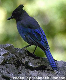
Tuesday morning's weather was cold and damp, with drizzle off and on. I was up nearly an hour and a half before my field partners, but I didn't have the heart to shake their tent, what with the rain and all. So I made some oatmeal and then watched the birds while I sipped coffee. We were only about a thousand feet higher than my house, but up in the Ponderosa/Douglas fir forests, the birds are quite a bit different. For instance, there are Steller's jays up in the tall trees, but not in the scrubby forest where I live.
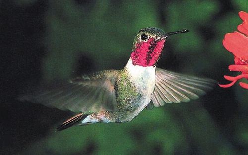
One bird that seems to be everywhere, though, is the broad-tailed hummingbird. I grew up with hummingbirds back East, but they were hard to notice - so fast, and so little, and so quiet. But the broad-tailed hummingbirds make this loud buzzing noise when they fly - it sounds almost like an insect, or like high-voltage power lines, or like somebody running a blender in the distance. So these birds, I notice. For some reason they fly up at the elevation of the Ponderosa branches, rather than down where all the small flowers are blooming. Maybe their nests are up there. But they still pause and hover at each branch for a moment, as if they expect the pines to suddenly burst into flower.
So I was watching the hummingbirds hum, when suddenly, one appeared about six inches in front of my face. I looked at him. He looked at me. He hovered for a moment, eyeing my red coffee mug, then zipped away.
I guess he was a coffee purist, and was horrified that I add hot chocolate to mine.
Or maybe it's just that a bird whose wings beat 50 times in a second doesn't really need caffeine.